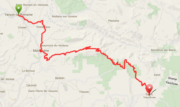
Day 11 Vaison La Romaine to Sault (mt Ventoux) 38 miles
Garmin file: https://connect.garmin.com/course/8522360 Elevation Gain: estimated – 2013m
Overview
Today if you choose to do so you will be ascending Mt Ventoux. You certainly don’t have to, there is a route round the mountain which, although still hilly and hard in sections, has a long stint along the valley floor which is quite flat and it is a shorter route round. For those attempting the climb the brew van will be waiting at the start of the climb to brief you and will also be there on the ascent and hopefully catch you at the top if they’re quick enough. Just after you descend there is the opportunity to have a bite to eat at Chalet Reynard but the van will be in Sault with sandwiches as well if you are hungry.
Practical Notes
The Garmin files start from the Roman Bridge
Ventoux bikes in the centre of Maulacene has Ventoux shirts, caps etc for sale that are cheaper than the shop at the top.
The guides will brief you about Ventoux before you ascend.
Remember to take and drink plenty of water.
Map

Elevation Profile

Start point – The Roman Bridge at 8:15
Lunch – Picnic sandwich lunch in Sault, or just after the top of Ventoux at Chalet Reynard if you wish.
Evening meal – Le Louvre at 7:00
Route Notes
Miles Route
0 If you are staying in Le Fete, Le Beffroi, Logis du Chateau then make your way to the Roman bridge for 8.30. You will have the brief just near the bridge, look out for one of the guides. After the brief cross over the bridge and go R.
0.6 Further along continue over a bridge and you will meet with a main road and go R. Traffic can go quite fast along here so please take care.
After a few hundred metres turn L along the D151 to St Marcellion les Vaison.
1.4 At the mini r-bout go R to Faucon 8 along the D205. Stay on this road for a few miles.
3.6 The road will bend sharp L. You need to turn R here to Entrechaux.
After a few hundred meters you will go over an attractive narrow bridge. On the other side of the bridge go R and follow the road up.
4.6 At the r-bout go R (1st exit) to Malaucene. Continue to Entrechaux and look out for the Office de Tourism on your L and go L just before the tourist office along Chemin de Champ-Long. Stay on this road.
7.0 You will come to a T-jcn. Go R here and continue into Malaucene.
8.1 In the centre of Malaucene you will come to a T-jcn. Go L here and continue through the town past cafes, bike shops etc. There are some toilets on your R along here.
8.3 At the top end of town go L along the D974 to Le Mont Ventoux 21.
You will now be climbing the iconic Mont Ventoux. A little further along the way the brew van will be at a camping place on the R just to brief you and feed and water you before the climb.
The brew van will also stop half way up somewhere and will try to catch you at the top as well if possible but if not then please take a good breather, drink plenty of water, eat a bit of food and take your time on the descent..
17.6 At the r-bout keep R.
21.4 Arrive at the summit of Mont Ventoux and give yourself a pat on the back. Now you will have the long descent to Sault. There is a small café at the top.
25.0 There is a restaurant if you need it although we will have a picnic lunch just before you enter Sault.
Not long after the restaurant you need to turn off to the L to get to Sault 20.
Now simply follow the road down to Sault. Please take extra care as you can easily overshoot and go over the edge if you’re not careful.
38.0 When you come into Sault for Autres Directions and Centre Ville and when you see a sign for La Louvre Hotel. Go R here for the hotel.
Hotel Le Louvre 0033 0490 640 888
Place du Marche, 84390 Sault.